1921 Map of Bellaire
USGS Topo · Published 1921About this map
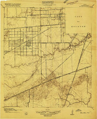
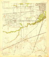
The western expansion of Houston in the mid-1910s reveals a transition from organized urban grids to the agricultural and institutional landscapes of Harris County. The Bellaire settlement stands at the intersection of several significant transport corridors, including Bellaire Boulevard and the San Antonio and Aransas Pass railroad. Local education and social services are prominent, marked by the Poor Farm and several specialized institutions like the Girls Industrial School and the prestigious Rice Institute grounds. Southern Houston's drainage and ecology are defined by the meandering courses of Brays Bayou and Sims Bayou, while the landscape further south around Pierce Junction and Myrtle is etched with numerous smaller topographical depressions. This era shows the early infrastructure of the S. P. System and Great Northern rail lines that fueled the region's industrial growth.
Find a feature on this map
35 named features on this map. Tap any name to fly to it.
Don’t see what you’re looking for? This feature index may not catch every label — zoom into the map to look around manually.
Map Details
Editions of this 1921 Bellaire Map
This is the sole edition of this map. No revisions or reprints were ever made.
Historical Maps of Houston Through Time
5 maps found