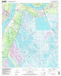
1999 Map of Belle Chasse
USGS Topo · Published 2000About this map
Belle Chasse Ferry provides a vital link across the Mississippi River, connecting the western bank's industrial and military hubs to the eastern marshlands. This landscape is defined by the sharp transition between the engineered river corridor and the sprawling wetlands of Big Mar and Lake Lery. Along the western levee, the U S N Air Station and Sea Train Terminal signal the area's mid-century strategic importance. In contrast, the eastern bank preserves older settlement patterns, with communities like St Clair, Scarsdale, and Dalcour clustered along narrow ridges of high ground. Local history is anchored by landmarks such as Bethlehem Ch and the English Turn Cem, while the Old Railroad Grade traces a vanished transport route through the parish. The map captures a moment before significant coastal changes, showing an intricate network of waterways including the Forty Arpent Canal and Delacroix Canal.
Find a feature on this map
39 named features on this map. Tap any name to fly to it.
Don’t see what you’re looking for? This feature index may not catch every label — zoom into the map to look around manually.
Map Details
Editions of this 1999 Belle Chasse Map
This is the sole edition of this map. No revisions or reprints were ever made.
Other maps of this area

1891 · Pointe a La Hache
USGS Topo · 1:62,500

1891 · New Orleans
USGS Topo · 1:62,500

1892 · Barataria
USGS Topo · 1:62,500

1892 · St. Bernard
USGS Topo · 1:62,500

1892 · Pointe a La Hache
USGS Topo · 1:62,500

1932 · New Orleans NE
USGS Topo · 1:31,680

1932 · New Orleans SE
USGS Topo · 1:31,680

1935 · Delacroix
USGS Topo · 1:31,680

1935 · Lake Batola
USGS Topo · 1:31,680
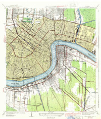
1939 · New Orleans East
USGS Topo · 1:31,680