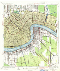
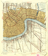
1939 Map of New Orleans East
USGS Topo · Published 1939About this map
New Orleans follows the crescent curve of the Mississippi River in this 1930s survey, illustrating the city's intricate relationship with its water-dominated landscape. The map reveals the dense urban grid of the French Quarter and surrounding wards, where the St Louis Cathedral stands near the riverfront. Extensive canal systems, including the Navigation Canal and Outfall Canal, define the drainage and transport infrastructure of the era, while the sprawling grounds of City Park and the Fairgrounds provide significant open spaces within the municipal fabric. Across the river, the communities of Algiers, Gretna, and McDonoghville are clearly delineated alongside the U S Naval Base. This survey also documents the academic and social landscape of the time, capturing the locations of Tulane University, Loyola University, and Dillard University, alongside major medical and charitable facilities like Charity Hospital and Hope Haven Institute.
Find a feature on this map
57 named features on this map. Tap any name to fly to it.
Don’t see what you’re looking for? This feature index may not catch every label — zoom into the map to look around manually.
Map Details
Editions of this 1939 New Orleans East Map
3 editions found

Other maps of this area

1891 · Spanish Fort
USGS Topo · 1:62,500

1891 · New Orleans
USGS Topo · 1:62,500

1892 · Chef Menteur
USGS Topo · 1:62,500

1892 · St. Bernard
USGS Topo · 1:62,500

1932 · New Orleans NE
USGS Topo · 1:31,680

1932 · New Orleans NW
USGS Topo · 1:31,680

1932 · New Orleans SE
USGS Topo · 1:31,680

1932 · New Orleans SW
USGS Topo · 1:31,680

1936 · Chef Menteur
USGS Topo · 1:62,500

1936 · Spanish Fort
USGS Topo · 1:62,500