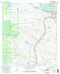
1974 Map of Belle Rose
USGS Topo · Published 1975About this map
The Mississippi River and Bayou Lafourche dictate the cultural geography of this Louisiana river country, where long-lot land divisions stretch back from the water's edge into the surrounding wetlands. This 1974 survey captures the dense ribbon of settlements following the levees, centered on the historic river town of Donaldsonville and extending south through Smoke Bend, Belle Rose, and Klotzville. The landscape is a transition between the industrial and agricultural, featuring the Texas and Pacific railroad line, a Gas and Oil Field, and active Crawfish Farms. This period shows several private airfields, including the Lane-Air Landing Strip and Belle Alliance Landing Strip, serving the local sugar and chemical interests. Researchers can trace family-named sites like Barton and Kessler, along with the small community of Freetown and the Virginia Ch church.
Find a feature on this map
46 named features on this map. Tap any name to fly to it.
Don’t see what you’re looking for? This feature index may not catch every label — zoom into the map to look around manually.
Map Details
Editions of this 1974 Belle Rose Map
This is the sole edition of this map. No revisions or reprints were ever made.
Other maps of this area

1892 · Donaldsonville
USGS Topo · 1:62,500

1892 · Thibodaux
USGS Topo · 1:62,500

1927 · Thibodaux NW
USGS Topo · 1:31,680

1935 · Gonzales
USGS Topo · 1:31,680

1936 · White Castle
USGS Topo · 1:62,500

1939 · Donaldsonville
USGS Topo · 1:62,500

1940 · Madewood
USGS Topo · 1:31,680

1945 · New Orleans
USGS Topo · 1:250,000

1947 · Donaldsonville
USGS Topo · 1:31,680

1953 · Napoleonville
USGS Topo · 1:62,500