
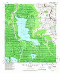
1953 Map of Napoleonville
USGS Topo · Published 1953About this map
Napoleonville and the surrounding river-and-rail corridor along Bayou Lafourche anchor the eastern half of this 1953 survey, showcasing the dense linear settlement patterns of the Louisiana sugar belt. The map documents numerous historic agricultural estates including Little Texas Plantation, Oakley Plantation, and Ravenwood Plantation, each situated on the higher natural levees. Beyond the cultivated land, the landscape transitions into the watery expanse of Lake Verret and the Belle River, where industry is represented by the Lake Verret Oil Field and the West Lake Verret Oil and Gas Field. The intricate network of smaller waterways like Bayou Magazille and Bayou Long contrasts with the industrial activity of the Texas and Pacific and Southern Pacific railroads that connect settlements such as Paincourtville and Plattenville.
Find a feature on this map
68 named features on this map. Tap any name to fly to it.
Don’t see what you’re looking for? This feature index may not catch every label — zoom into the map to look around manually.
Map Details
Editions of this 1953 Napoleonville Map
2 editions found
Other maps of this area

1892 · Gibson
USGS Topo · 1:62,500

1892 · Donaldsonville
USGS Topo · 1:62,500

1892 · Thibodaux
USGS Topo · 1:62,500

1897 · Gibson
USGS Topo · 1:62,500

1927 · Thibodaux NW
USGS Topo · 1:31,680

1932 · Thibodaux SW
USGS Topo · 1:31,680

1935 · Morgan City
USGS Topo · 1:62,500

1935 · Chicot Lake
USGS Topo · 1:62,500

1936 · White Castle
USGS Topo · 1:62,500

1938 · Labadieville
USGS Topo · 1:24,000