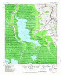
1953 Map of Napoleonville
USGS Topo · Published 1966About this map
Napoleonville and the winding Lafourche corridor dominate the eastern portion of this mid-century survey, where a dense network of sugarcane plantations and small settlements lines the waterway. Large holdings such as Little Texas Plantation and Oakley Plantation characterize the local agricultural landscape, while the Texas and Pacific RR and Southern Pacific RR provide the critical rail links for transport. To the west, the environment shifts dramatically into the vast swamps and basins of the Atchafalaya region. The massive expanse of Lake Verret serves as a central landmark, flanked by the East Lake Verret Oil Field and the West Lake Verret Oil and Gas Field, signaling the emergence of the petroleum industry alongside traditional river life. Waterways like Belle River and Attakapas Canal weave through the marshland, connecting the interior basins to the settled ridges.
Find a feature on this map
69 named features on this map. Tap any name to fly to it.
Don’t see what you’re looking for? This feature index may not catch every label — zoom into the map to look around manually.
Map Details
Editions of this 1953 Napoleonville Map
2 editions found

Other maps of this area

1892 · Gibson
USGS Topo · 1:62,500

1892 · Donaldsonville
USGS Topo · 1:62,500

1892 · Thibodaux
USGS Topo · 1:62,500

1897 · Gibson
USGS Topo · 1:62,500

1927 · Thibodaux NW
USGS Topo · 1:31,680

1932 · Thibodaux SW
USGS Topo · 1:31,680

1935 · Morgan City
USGS Topo · 1:62,500

1935 · Chicot Lake
USGS Topo · 1:62,500

1936 · White Castle
USGS Topo · 1:62,500

1938 · Labadieville
USGS Topo · 1:24,000