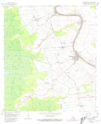
1965 Map of Napoleonville
USGS Topo · Published 1981About this map
Bayou Lafourche serves as the central artery for this portion of Assumption Parish, where tight-knit settlements and industrial junctions follow the natural curve of the waterway. The 1960s landscape shows a transition from traditional river-bound life to a specialized economy, marked by the East Lake Verret Gas Field and a network of sugar-related names like Westfield, Glenwood, and Elm Hall. The area around Napoleonville is densely detailed, showing the Waterworks, Sewage Disposal, and the critical rail crossings at Elm Hall Junction.
Find a feature on this map
49 named features on this map. Tap any name to fly to it.
Don’t see what you’re looking for? This feature index may not catch every label — zoom into the map to look around manually.
Map Details
Editions of this 1965 Napoleonville Map
Other maps of this area

1892 · Donaldsonville
USGS Topo · 1:62,500

1892 · Thibodaux
USGS Topo · 1:62,500

1927 · Thibodaux NW
USGS Topo · 1:31,680

1932 · Thibodaux SW
USGS Topo · 1:31,680

1936 · White Castle
USGS Topo · 1:62,500

1938 · Labadieville
USGS Topo · 1:24,000

1939 · Donaldsonville
USGS Topo · 1:62,500

1940 · Madewood
USGS Topo · 1:31,680

1945 · New Orleans
USGS Topo · 1:250,000

1947 · Donaldsonville
USGS Topo · 1:31,680