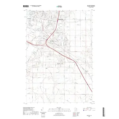
2018 Map of Bellevue
USGS Topo · Published 2018About this map
The suburban and rural landscape of Brown County unfolds here, showing the southward expansion of the Green Bay area into the village of Bellevue and the town of Allouez. While the northern portion of the map is defined by dense residential streets and industrial corridors along the East River, the southern reaches transition into a patchwork of farmland and creek valleys. Notable landmarks include the Fonferek Glen Natural Arch and the prominent Scray Hill to the southwest. This topographic study captures the community just as modern infrastructure began to weave through older rural hamlets like Kolb and Pine Grove, where the Polish Cem and Martins Aerodrome serve as evidence of the area's agricultural and local aviation heritage. The drainage patterns of Bairds Creek and the Neshota River further define the geological character of this transitioning Wisconsin landscape.
Find a feature on this map
210 named features on this map. Tap any name to fly to it.
Don’t see what you’re looking for? This feature index may not catch every label — zoom into the map to look around manually.
Map Details
Editions of this 2018 Bellevue Map
This is the sole edition of this map. No revisions or reprints were ever made.
Other maps of this area

1954 · De Pere
USGS Topo · 1:62,500

1954 · Green Bay West
USGS Topo · 1:24,000

1954 · Denmark
USGS Topo · 1:62,500

1954 · De Pere
USGS Topo · 1:24,000

1954 · New Franken
USGS Topo · 1:62,500

1954 · Green Bay East
USGS Topo · 1:24,000

1954 · Manitowoc
USGS Topo · 1:250,000

1954 · Bellevue
USGS Topo · 1:24,000

1954 · Green Bay
USGS Topo · 1:62,500

1955 · Green Bay
USGS Topo · 1:250,000