
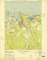
1947 Map of Bellport
USGS Topo · Published 1947About this map
Bellport Bay and the tidal reaches of the Carmans River anchor this 1940s-era coastal landscape, which was prepared by the Army Map Service during World War II. The map reveals a transition from the developing shoreline communities of Bellport and Brookhaven to the agricultural and institutional interior. Notably, it documents the Suffolk County Alms House & Childrens Home and the sprawling Camp Upton Military Reservation, providing a clear record of local social and military infrastructure before the post-war suburban boom. The area's transit spine is defined by the Long Island Railroad and its Montauk Division, with stops at Medford Sta, Plainfield Sta, and Yaphank Sta connecting these South Shore villages. Inland, the terrain rises toward Coram Hill, while the local economy is evidenced by numerous clusters of Greenhouses and Chimney Greenhouses.
Find a feature on this map
45 named features on this map. Tap any name to fly to it.
Don’t see what you’re looking for? This feature index may not catch every label — zoom into the map to look around manually.
Map Details
Editions of this 1947 Bellport Map
This is the sole edition of this map. No revisions or reprints were ever made.
Other maps of this area

1902 · Setauket
USGS Topo · 1:62,500

1902 · Fire Island
USGS Topo · 1:62,500

1903 · Fire Island
USGS Topo · 1:62,500

1904 · Setauket
USGS Topo · 1:62,500

1904 · Islip
USGS Topo · 1:125,000

1904 · Moriches
USGS Topo · 1:62,500

1919 · Setauket
USGS Topo · 1:62,500

1942 · Islip
USGS Topo · 1:125,000

1947 · Howells Point
USGS Topo · 1:24,000
1947 · Port Jefferson
USGS Topo · 1:24,000