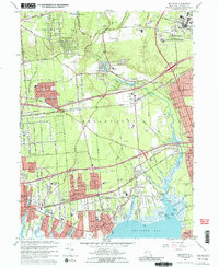
1967 Map of Bellport
USGS Topo · Published 1989About this map
Brookhaven National Laboratory occupies a significant portion of this central Long Island landscape, appearing alongside growing mid-century suburban developments and older rural hamlets. The map documents a period of rapid infrastructure expansion, dominated by the paths of the Long Island Railroad and the newly established Long Island Expressway. These transit corridors cut through the woodlands and wetlands of Brookhaven, connecting interior settlements like Yaphank and Medford to the south shore's coastal communities. Along the edge of Bellport Bay, the settlement patterns of Bellport, North Bellport, and Hagerman show dense residential grids. Local life is detailed through numerous neighborhood anchors, including St Andrews Ch, the Eagle Drive Sch, and Brookhaven Memorial Hospital. The preservation of natural features like Carmans River and Spring Lake contrasts with the industrial activity visible at the local Gravel Pit.
Find a feature on this map
90 named features on this map. Tap any name to fly to it.
Don’t see what you’re looking for? This feature index may not catch every label — zoom into the map to look around manually.
Map Details
Editions of this 1967 Bellport Map
Other maps of this area

1902 · Setauket
USGS Topo · 1:62,500

1902 · Fire Island
USGS Topo · 1:62,500

1903 · Fire Island
USGS Topo · 1:62,500

1904 · Setauket
USGS Topo · 1:62,500

1904 · Islip
USGS Topo · 1:125,000

1904 · Moriches
USGS Topo · 1:62,500

1919 · Setauket
USGS Topo · 1:62,500

1942 · Islip
USGS Topo · 1:125,000

1947 · Bellport
USGS Topo · 1:24,000

1947 · Howells Point
USGS Topo · 1:24,000