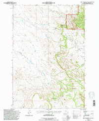
1993 Map of Belltower Butte
USGS Topo · Published 1996About this map
Belltower Church sits at the center of this Montana landscape, where the arid high plains meet the western edge of the Custer National Forest. The map documents a sparsely populated ranching and forest environment characterized by dramatic geological formations like Belltower Butte and Chimney Rock. Water management is central to the area's utility, evidenced by the Dewdrop Reservoir and numerous drainages including Skull Creek and Calamount Creek. Local history is anchored by family-named landmarks such as the J Yates Ranch and Meyers, while a solitary Grave near the church provides a specific point of interest for genealogists. The presence of Tie Road and a Gravel Pit indicates the local infrastructure and industry within this section of Carter County during the early 1990s.
Find a feature on this map
20 named features on this map. Tap any name to fly to it.
Don’t see what you’re looking for? This feature index may not catch every label — zoom into the map to look around manually.
Map Details
Editions of this 1993 Belltower Butte Map
This is the sole edition of this map. No revisions or reprints were ever made.
Other maps of this area

1954 · Ekalaka
USGS Topo · 1:250,000

1956 · Ekalaka
USGS Topo · 1:250,000

1958 · Ekalaka
USGS Topo · 1:250,000

1965 · Ekalaka
USGS Topo · 1:250,000

1980 · Taylor Hills
USGS Topo · 1:24,000

1980 · Belltower
USGS Topo · 1:24,000

1980 · Prairie Dog Creek
USGS Topo · 1:24,000
1980 · Rustler Divide
USGS Topo · 1:24,000

1980 · Belltower Butte
USGS Topo · 1:24,000
1980 · School Section Creek
USGS Topo · 1:24,000