
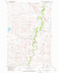
1980 Map of Taylor Hills
USGS Topo · Published 1980About this map
The Taylor Hills dominate this high-plains landscape in southeastern Montana, where the watershed is defined by the Dead Boy Divide. This 1980 survey captures a region of sparse settlement characterized by extensive rangeland and isolated water sources. The drainage network is complex, featuring Boxelder Creek, Sand Creek, and the seasonal Soda Lakes to the northwest. Historical land use is evident through features like the Lone Tree Road, which winds through the southern hills, and various water management markers such as a Drill Hole and scattered Well sites.
Find a feature on this map
20 named features on this map. Tap any name to fly to it.
Don’t see what you’re looking for? This feature index may not catch every label — zoom into the map to look around manually.
Map Details
Editions of this 1980 Taylor Hills Map
This is the sole edition of this map. No revisions or reprints were ever made.
Other maps of this area

1954 · Ekalaka
USGS Topo · 1:250,000

1956 · Ekalaka
USGS Topo · 1:250,000

1958 · Ekalaka
USGS Topo · 1:250,000

1965 · Ekalaka
USGS Topo · 1:250,000

1979 · Dead Boy Divide
USGS Topo · 1:24,000

1979 · Ikey Creek
USGS Topo · 1:24,000

1980 · Belltower
USGS Topo · 1:24,000

1980 · Belltower Butte
USGS Topo · 1:24,000

1980 · Camp Needmore
USGS Topo · 1:24,000
1980 · School Section Creek
USGS Topo · 1:24,000