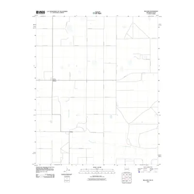
2010 Map of Bellview
USGS Topo · Published 2010About this map
The settlement of Bellview and the nearby community of Hollene define the rural landscape of this high plains border region. In the early 21st century, the area maintained its identity through landmarks like the Bellview Post Office, situated at the junction of local transit routes. The terrain is marked by the meandering path of Tierra Blanca Creek, which winds across the southern portion of the quadrangle, providing a natural contrast to the rigid grid of the surrounding road system. Significant arteries such as State Line Rd underscore the location's proximity to the Texas border, while a network of rural routes including Curry Road 42 and Fm 1058 facilitate travel between scattered farmsteads. This map reflects the enduring agricultural character of Curry County, documenting the specific placement of buildings and water features that have shaped local life for generations.
Find a feature on this map
27 named features on this map. Tap any name to fly to it.
Don’t see what you’re looking for? This feature index may not catch every label — zoom into the map to look around manually.
Map Details
Editions of this 2010 Bellview Map
This is the sole edition of this map. No revisions or reprints were ever made.
Other maps of this area

1954 · Clovis
USGS Topo · 1:250,000

1957 · Pleasant Hill
USGS Topo · 1:62,500

1958 · Clovis
USGS Topo · 1:250,000

1965 · Rhea
USGS Topo · 1:24,000

1971 · Mustang Lake
USGS Topo · 1:24,000

1971 · Garcia Lake
USGS Topo · 1:24,000

1971 · Day Canyon
USGS Topo · 1:24,000

1971 · Broadview
USGS Topo · 1:24,000

1971 · Bellview
USGS Topo · 1:24,000
1971 · Endee Hill
USGS Topo · 1:24,000