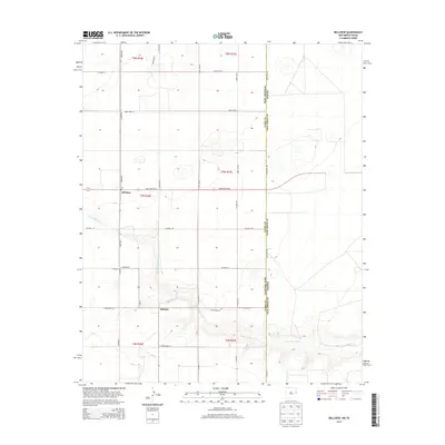
2013 Map of Bellview
USGS Topo · Published 2013About this map
The high plains of eastern New Mexico meet the Texas state line in this landscape defined by the intersection of Curry and Deaf Smith counties. The community of Bellview serves as a local anchor along State Route 241, where a central Po marks the settlement's civic presence. To the south, the village of Hollene sits near the headwaters of Tierra Blanca Cr, which carves a distinct path through the township sections of the Llano Estacado. The geometric precision of the Public Land Survey System is visible through a dense network of local routes, including Curry Road 42 and Curry Road 36, reflecting the region's enduring agricultural organization. This 2013 survey provides a clear view of the rural infrastructure and drainage patterns that have shaped the borderland ranching and farming economy for generations.
Find a feature on this map
21 named features on this map. Tap any name to fly to it.
Don’t see what you’re looking for? This feature index may not catch every label — zoom into the map to look around manually.
Map Details
Editions of this 2013 Bellview Map
This is the sole edition of this map. No revisions or reprints were ever made.
Other maps of this area

1954 · Clovis
USGS Topo · 1:250,000

1957 · Pleasant Hill
USGS Topo · 1:62,500

1958 · Clovis
USGS Topo · 1:250,000

1965 · Rhea
USGS Topo · 1:24,000

1971 · Mustang Lake
USGS Topo · 1:24,000

1971 · Garcia Lake
USGS Topo · 1:24,000

1971 · Day Canyon
USGS Topo · 1:24,000

1971 · Broadview
USGS Topo · 1:24,000

1971 · Bellview
USGS Topo · 1:24,000
1971 · Endee Hill
USGS Topo · 1:24,000