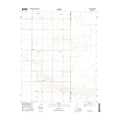
2017 Map of Bellview
USGS Topo · Published 2017About this map
The small communities of Bellview and Hollene anchor this high plains landscape along the border of eastern New Mexico and the Texas Panhandle. The topography is defined by the gradual descent of Tierra Blanca Cr, which carves distinct drainage patterns across the otherwise steady terrain of Curry County. A rigid grid of section roads, including Curry Rd E and Curry Road B, reveals the systematic agricultural development of the region, where every square mile is accessible for dryland farming or ranching. The sharp vertical line of State Line Rd marks the boundary between New Mexico and Texas, specifically dividing Curry and Deaf Smith counties. This 2017 survey captures the intersection of traditional land use and modern infrastructure, including Ranch Rd 1058 and several numbered local routes like Curry Road 36 that connect these remote farming outposts.
Find a feature on this map
32 named features on this map. Tap any name to fly to it.
Don’t see what you’re looking for? This feature index may not catch every label — zoom into the map to look around manually.
Map Details
Editions of this 2017 Bellview Map
This is the sole edition of this map. No revisions or reprints were ever made.
Other maps of this area

1954 · Clovis
USGS Topo · 1:250,000

1957 · Pleasant Hill
USGS Topo · 1:62,500

1958 · Clovis
USGS Topo · 1:250,000

1965 · Rhea
USGS Topo · 1:24,000

1971 · Mustang Lake
USGS Topo · 1:24,000

1971 · Garcia Lake
USGS Topo · 1:24,000

1971 · Day Canyon
USGS Topo · 1:24,000

1971 · Broadview
USGS Topo · 1:24,000

1971 · Bellview
USGS Topo · 1:24,000
1971 · Endee Hill
USGS Topo · 1:24,000