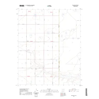
2023 Map of Bellview
USGS Topo · Published 2023About this map
Hollene and Bellview anchor this High Plains landscape along the New Mexico and Texas border. The terrain is defined by the ephemeral drainage of Tierra Blanca Creek, which cuts through the southern reaches of the map, contrasting with the rigid section-line grid of the surrounding agricultural land. Local history is centered on the small rural community at Hollene, where the Hollene Cem remains a primary point of interest for genealogists and researchers tracing the families who settled this portion of Curry County. The map clearly delineates the New Mexico Texas state line, followed closely by State Line Rd, showing how geopolitical boundaries dictated the development of the regional road network including Curry Road B and Ranch Rd 1058.
Find a feature on this map
32 named features on this map. Tap any name to fly to it.
Don’t see what you’re looking for? This feature index may not catch every label — zoom into the map to look around manually.
Map Details
Editions of this 2023 Bellview Map
This is the sole edition of this map. No revisions or reprints were ever made.
Other maps of this area

1954 · Clovis
USGS Topo · 1:250,000

1957 · Pleasant Hill
USGS Topo · 1:62,500

1958 · Clovis
USGS Topo · 1:250,000

1965 · Rhea
USGS Topo · 1:24,000

1971 · Mustang Lake
USGS Topo · 1:24,000

1971 · Garcia Lake
USGS Topo · 1:24,000

1971 · Day Canyon
USGS Topo · 1:24,000

1971 · Broadview
USGS Topo · 1:24,000

1971 · Bellview
USGS Topo · 1:24,000
1971 · Endee Hill
USGS Topo · 1:24,000