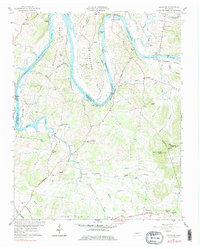
1958 Map of Bellwood
USGS Topo · Published 1978About this map
Beasleys Bend and Puryears Bend dominate this landscape, where the Cumberland River carves deep loops along the border of Wilson and Trousdale counties. The 1950s era represented here shows the river transformed into Old Hickory Lake, with the water level reaching the spillway elevation and surrounding landmarks like Whitleys Bluff and Mitchells Bluff. Settlement patterns are defined by small rural hubs such as Centerville, Taylorsville, and Bellwood, each anchored by community institutions like King Sch and Goshen Ch.
Find a feature on this map
57 named features on this map. Tap any name to fly to it.
Don’t see what you’re looking for? This feature index may not catch every label — zoom into the map to look around manually.
Map Details
Editions of this 1958 Bellwood Map
3 editions found
Other maps of this area

1942 · Statesville
USGS Topo · 1:100,000

1942 · Gallatin
USGS Topo · 1:100,000

1942 · Lebanon
USGS Topo · 1:100,000

1951 · Lebanon
USGS Topo · 1:24,000

1955 · Bethpage
USGS Topo · 1:24,000

1955 · Hunters Point
USGS Topo · 1:24,000

1956 · Nashville
USGS Topo · 1:250,000

1958 · New Middleton
USGS Topo · 1:24,000

1958 · Bellwood
USGS Topo · 1:24,000

1958 · Dixon Springs
USGS Topo · 1:24,000