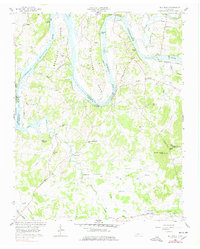
1958 Map of Bellwood
USGS Topo · Published 1978About this map
Cumberland River loops through this landscape, defining the sharp meanders of Beasleys Bend and Puryears Bend as it flows toward Old Hickory Lake. The terrain is characterized by prominent bluffs like Whitleys Bluff and Belchers Bluff, which overlook the fertile river bottoms and the wooded ridges of the Central Basin. During this mid-century period, the area maintained a rural, decentralized settlement pattern, with small communities like Bellwood, Centerville, and Taylorsville serving as local hubs.
Find a feature on this map
53 named features on this map. Tap any name to fly to it.
Don’t see what you’re looking for? This feature index may not catch every label — zoom into the map to look around manually.
Map Details
Editions of this 1958 Bellwood Map
3 editions found
Other maps of this area

1942 · Statesville
USGS Topo · 1:100,000

1942 · Gallatin
USGS Topo · 1:100,000

1942 · Lebanon
USGS Topo · 1:100,000

1951 · Lebanon
USGS Topo · 1:24,000

1955 · Bethpage
USGS Topo · 1:24,000

1955 · Hunters Point
USGS Topo · 1:24,000

1956 · Nashville
USGS Topo · 1:250,000

1958 · New Middleton
USGS Topo · 1:24,000

1958 · Bellwood
USGS Topo · 1:24,000

1958 · Dixon Springs
USGS Topo · 1:24,000