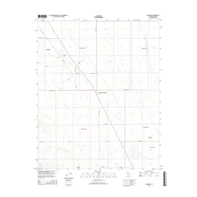
2015 Map of Belridge
USGS Topo · Published 2015About this map
Missouri Triangle and the small settlement of Belridge serve as focal points for this portion of the western San Joaquin Valley, where the industrial character of the oil fields meets the vast infrastructure of the Central Valley. The landscape is defined by a dense network of roads supporting local resource extraction, including Discovery Well Rd, Roustabout Rd, and Poleline Rd. These routes crisscross the arid terrain, leading toward the Temblor Valley and seasonal drainage paths like Chico Martinez Cr and Salt Cr. To the east, the massive Governor Edmund G Brown California Aqueduct cuts a straight line across the valley floor, illustrating the scale of water engineering necessary to sustain this region. The map highlights the intersection of transportation and utility, with the Lerdo Hwy and W Side Hwy framing the area's development.
Find a feature on this map
31 named features on this map. Tap any name to fly to it.
Don’t see what you’re looking for? This feature index may not catch every label — zoom into the map to look around manually.
Map Details
Editions of this 2015 Belridge Map
This is the sole edition of this map. No revisions or reprints were ever made.
Other maps of this area

1912 · McKittrick
USGS Topo · 1:125,000

1914 · Lost Hills
USGS Topo · 1:125,000

1927 · Semitropic
USGS Topo · 1:31,680

1931 · Lokern
USGS Topo · 1:31,680

1931 · Goose Lake
USGS Topo · 1:31,680

1932 · West Elk Hills
USGS Topo · 1:31,680

1932 · West of Goose Lake
USGS Topo · 1:31,680

1934 · Lokern
USGS Topo · 1:31,680

1934 · West of Goose Lake
USGS Topo · 1:31,680
1942 · Hart Station
USGS Topo · 1:62,500