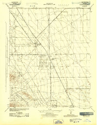
1943 Map of Belridge
USGS Topo · Published 1943About this map
Industrial expansion in the San Joaquin Valley is clearly defined by the oil infrastructure documented during the Second World War. The landscape is dominated by the operations of the Belridge Oil Co and the General Petroleum Corp South Belridge Lease Camp, where specialized lease camps supported the workforce required for large-scale extraction. These settlements, alongside the Belridge Oil Co South Belridge Lease Camp, provide a focused look at the company-town model that shaped Kern County's petroleum districts.
Find a feature on this map
17 named features on this map. Tap any name to fly to it.
Don’t see what you’re looking for? This feature index may not catch every label — zoom into the map to look around manually.
Map Details
Editions of this 1943 Belridge Map
This is the sole edition of this map. No revisions or reprints were ever made.
Other maps of this area

1912 · McKittrick
USGS Topo · 1:125,000

1914 · Lost Hills
USGS Topo · 1:125,000

1927 · Semitropic
USGS Topo · 1:31,680

1931 · Lokern
USGS Topo · 1:31,680

1931 · Goose Lake
USGS Topo · 1:31,680

1932 · West Elk Hills
USGS Topo · 1:31,680

1932 · West of Goose Lake
USGS Topo · 1:31,680

1934 · Lokern
USGS Topo · 1:31,680

1934 · West of Goose Lake
USGS Topo · 1:31,680
1942 · Hart Station
USGS Topo · 1:62,500