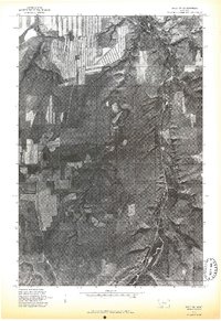
1975 Map of Belt SW
USGS Topo · Published 1975About this map
Armington sits at the northern confluence of two significant drainages in this 1975 orthophotoquad, which uses aerial imagery to document the transition between high plateau agriculture and the carved-out river bottoms. The landscape is defined by the deep, winding incision of Belt Creek as it runs north along the eastern edge of the sheet, contrasted by the more seasonal, branching path of Neel Creek through the center. Large-scale strip farming and dryland wheat patterns dominate the upland benches, revealing the 1970s land-use footprint in this part of Cascade County. The imagery provides a clear view of the road network and ranch access points as they follow the natural contours of the coulees and creek beds, providing a precise spatial record for researchers studying mid-century Montana agriculture or local family ranching history.
Find a feature on this map
3 named features on this map. Tap any name to fly to it.
Don’t see what you’re looking for? This feature index may not catch every label — zoom into the map to look around manually.
Map Details
Editions of this 1975 Belt SW Map
This is the sole edition of this map. No revisions or reprints were ever made.
Other maps of this area

1886 · Great Falls
USGS Topo · 1:250,000

1890 · Fort Benton
USGS Topo · 1:250,000

1892 · Fort Benton
USGS Topo · 1:250,000

1897 · Fort Benton
USGS Topo · 1:250,000

1954 · Great Falls
USGS Topo · 1:250,000

1955 · Stockett
USGS Topo · 1:62,500

1956 · Belt
USGS Topo · 1:62,500

1957 · Great Falls
USGS Topo · 1:250,000
1965 · Fife
USGS Topo · 1:24,000

1965 · Mahoney Hill
USGS Topo · 1:24,000