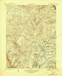
1945 Map of Beltsville
USGS Topo · Published 1945About this map
Xaverian College and several prominent academic and religious institutions anchor the landscape of northern Prince George's and eastern Montgomery counties during the mid-1940s. The region is defined by a transition from the agricultural operations of the National Agricultural Research Center and the Horticultural Station toward growing residential pockets like Greenbelt and Hollywood. Transport is dominated by the Baltimore and Ohio Railroad, which services small communities such as Ammendale, Muirkirk, and Beltsville. The terrain is deeply etched by the Paint Branch and Little Paint Branch creek systems, while historical infrastructure like the Willis Pumping Sta and various country schools—including Willis Sch and Colesville Sch—reveal the area's rural-to-suburban evolution. Notable landmarks such as Briarley Military Academy and Queens Chapel provide specific points of interest for local historians studying this wartime era.
Find a feature on this map
64 named features on this map. Tap any name to fly to it.
Don’t see what you’re looking for? This feature index may not catch every label — zoom into the map to look around manually.
Map Details
Editions of this 1945 Beltsville Map
3 editions found
Other maps of this area

1890 · Mt. Vernon
USGS Topo · 1:125,000

1891 · Mt. Vernon
USGS Topo · 1:125,000

1892 · Laurel
USGS Topo · 1:62,500

1893 · Frederick
USGS Topo · 1:125,000

1894 · Laurel
USGS Topo · 1:62,500

1894 · Frederick
USGS Topo · 1:125,000

1894 · Mt. Vernon
USGS Topo · 1:125,000

1897 · Laurel
USGS Topo · 1:62,500

1897 · Mt. Vernon
USGS Topo · 1:125,000

1899 · Patuxent
USGS Topo · 1:125,000