1968 Map of Belvidere
USGS Topo · Published 1970About this map
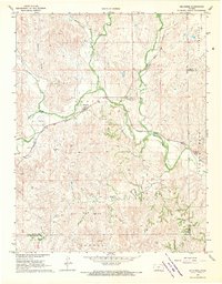
Belvidere sits at a strategic bend where the Medicine Lodge River meets the tracks of the Atchison Topeka and Santa Fe railroad, serving as the central hub of this Kiowa County landscape. The valley floor is defined by the river’s winding course, flanked by the Belvidere Cem and industrial markings such as a Gravel Pit and various quarries. North of the river, the terrain rises into the rolling uplands of Springvale, dissected by numerous watercourses including Spring Creek, Soldier Creek, and Thompson Branch.
Find a feature on this map
21 named features on this map. Tap any name to fly to it.
Don’t see what you’re looking for? This feature index may not catch every label — zoom into the map to look around manually.
Map Details
Editions of this 1968 Belvidere Map
This is the sole edition of this map. No revisions or reprints were ever made.
Other maps of this area

1889 · Kinsley
USGS Topo · 1:125,000

1891 · Medicine Lodge
USGS Topo · 1:125,000

1892 · Kinsley
USGS Topo · 1:125,000

1892 · Coldwater
USGS Topo · 1:125,000

1892 · Pratt
USGS Topo · 1:125,000

1893 · Medicine Lodge
USGS Topo · 1:125,000

1894 · Kinsley
USGS Topo · 1:125,000

1894 · Pratt
USGS Topo · 1:125,000

1955 · Pratt
USGS Topo · 1:250,000

1959 · Pratt
USGS Topo · 1:250,000
Featured Places
- Kiowa Rural Township, KS
- Belvidere, Kiowa Rural Township
- Kiowa County, KS
- Comanche County, KS
- Barber County, KS