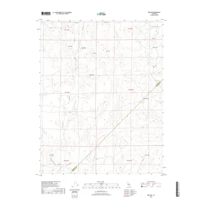
2018 Map of Ben Hur
USGS Topo · Published 2018About this map
Ben Hur sits in the high country of the Sierra Nevada foothills, a landscape defined by prominent granite outcrops and a network of seasonal creeks. This survey details the complex terrain where the Chowchilla River flows southwestward, carving through a series of named ridges and peaks. The map reveals a rural network of roads like Oak Grove RD and Ben Hur RD that follow the natural contours of the land, connecting scattered homesteads across the boundary between Mariposa and Madera counties.
Find a feature on this map
37 named features on this map. Tap any name to fly to it.
Don’t see what you’re looking for? This feature index may not catch every label — zoom into the map to look around manually.
Map Details
Editions of this 2018 Ben Hur Map
This is the sole edition of this map. No revisions or reprints were ever made.
Other maps of this area

1912 · Mariposa
USGS Topo · 1:125,000

1919 · Indian Gulch
USGS Topo · 1:48,000

1919 · Raynor Creek
USGS Topo · 1:31,680

1920 · Indian Gulch
USGS Topo · 1:62,500

1942 · Raymond
USGS Topo · 1:62,500

1944 · Raymond
USGS Topo · 1:62,500
1946 · Le Grand
USGS Topo · 1:62,500
1947 · Raynor Creek
USGS Topo · 1:24,000

1947 · Mariposa
USGS Topo · 1:24,000

1947 · San Jose
USGS Topo · 1:250,000