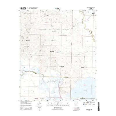
2014 Map of Ben Lomond
USGS Topo · Published 2014About this map
Ben Lomond and the surrounding southwestern Arkansas lowlands are defined by the winding course of the Little River, which serves as a natural boundary between Sevier and Little River counties. The landscape transitions from the upland settlements of Cowlingsville and Brownstown toward the expansive waters of Millwood Lake and a complex network of sloughs and oxbows, including Grassy Lake, Trout Lake, and Davis Slough. This modern survey illustrates how traditional rural communities are integrated into the riparian environment, with long-established sites like Ben Lomond Cem and Brownstown Cem providing vital touchpoints for local genealogy. The southern portion of the map highlights the distinct geographical features of White Cliffs and the wetlands along Big Slough, while the northeastern corner captures the community of Shiloh near the Saline River, reflecting the diverse water-based topography that has shaped settlement patterns in this region for generations.
Find a feature on this map
67 named features on this map. Tap any name to fly to it.
Don’t see what you’re looking for? This feature index may not catch every label — zoom into the map to look around manually.
Map Details
Editions of this 2014 Ben Lomond Map
This is the sole edition of this map. No revisions or reprints were ever made.
Other maps of this area

1950 · Ashdown East
USGS Topo · 1:24,000

1950 · Ashdown West
USGS Topo · 1:24,000

1950 · Red Bluff
USGS Topo · 1:24,000

1950 · Ben Lomond
USGS Topo · 1:24,000

1950 · Falls Chapel
USGS Topo · 1:24,000

1951 · Ben Lomond
USGS Topo · 1:24,000

1951 · Ashdown West
USGS Topo · 1:24,000

1951 · Red Bluff
USGS Topo · 1:24,000

1951 · Falls Chapel
USGS Topo · 1:24,000

1951 · Ashdown East
USGS Topo · 1:24,000