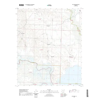
2020 Map of Ben Lomond
USGS Topo · Published 2020About this map
Ben Lomond and its surrounding communities are situated within a landscape defined by the convergence of the Saline River and the Little River. In this southwestern Arkansas territory, the topography shifts from the upland ridges of W Bois D'Arc Ridge to the broad, marshy lowlands of Millwood Lake. The map reveals a network of rural settlements, including White Cliffs, Brownstown, and Cowlingsville, each connected by routes like State Hwy 317 and State Hwy 234. Significant local history is preserved in the locations of Ben Lomond Cem, Wrights Chapel Cem, and Brownstown Cem. The presence of Lake Hospitality and Grassy Lake amidst the sloughs and bayous illustrates the intricate drainage patterns that have historically shaped land use and settlement in Sevier County.
Find a feature on this map
57 named features on this map. Tap any name to fly to it.
Don’t see what you’re looking for? This feature index may not catch every label — zoom into the map to look around manually.
Map Details
Editions of this 2020 Ben Lomond Map
This is the sole edition of this map. No revisions or reprints were ever made.
Other maps of this area

1950 · Ashdown East
USGS Topo · 1:24,000

1950 · Ashdown West
USGS Topo · 1:24,000

1950 · Red Bluff
USGS Topo · 1:24,000

1950 · Ben Lomond
USGS Topo · 1:24,000

1950 · Falls Chapel
USGS Topo · 1:24,000

1951 · Ben Lomond
USGS Topo · 1:24,000

1951 · Ashdown West
USGS Topo · 1:24,000

1951 · Red Bluff
USGS Topo · 1:24,000

1951 · Falls Chapel
USGS Topo · 1:24,000

1951 · Ashdown East
USGS Topo · 1:24,000