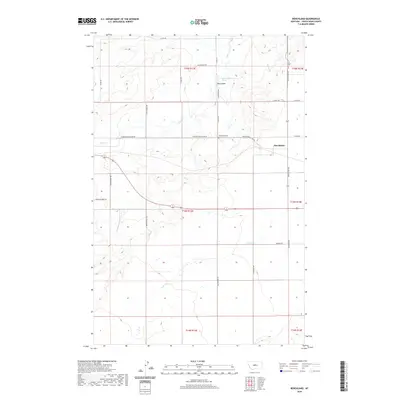
2020 Map of Benchland
USGS Topo · Published 2020About this map
The settlement of Benchland serves as the central focal point of this Judith Basin County landscape, situated where the high plains transition into organized agricultural and transit corridors. The township is supported by the Benchland Cem, located to the west along Windham Benchland Rd. The local hydrology is defined by the winding paths of Sage Cr and Louse Cr, which carve through the terrain alongside numerous springs, including the specifically noted 16N13E35BCD_01 Spring near Big Coulee. A network of rural routes and historic trails, such as Cottonwood Trl, Browns Hill Trl, and the aptly named Last Chance Rd, reveal the established movement patterns of this ranching and farming community. The map's layout emphasizes the rectangular survey system that has governed Montana's land use for over a century.
Find a feature on this map
30 named features on this map. Tap any name to fly to it.
Don’t see what you’re looking for? This feature index may not catch every label — zoom into the map to look around manually.
Map Details
Editions of this 2020 Benchland Map
This is the sole edition of this map. No revisions or reprints were ever made.
Other maps of this area

1886 · Little Belt Mts.
USGS Topo · 1:250,000

1889 · Big Snowy Mountain
USGS Topo · 1:250,000

1890 · Fort Benton
USGS Topo · 1:250,000

1892 · Fort Benton
USGS Topo · 1:250,000

1893 · Big Snowy Mountain
USGS Topo · 1:250,000

1894 · Little Belt Mts.
USGS Topo · 1:250,000

1897 · Fort Benton
USGS Topo · 1:250,000

1897 · Little Belt Mts.
USGS Topo · 1:250,000

1898 · Little Belt Mts.
USGS Topo · 1:250,000

1902 · Little Belt Mts.
USGS Topo · 1:250,000