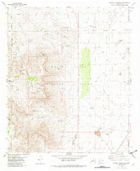
1981 Map of Bennett Mountain
USGS Topo · Published 1982About this map
The San Andres Mountains dominate this arid landscape, where the high desert terrain transitions into the restricted territory of the White Sands Missile Range. Water sources are the primary indicators of human activity and wildlife survival in this environment, marked by a series of isolated springs along the mountain slopes, including San Nicolas Spring, Bighorn Spring, and the numbered Bennett Spring No. 1 and Bennett Spring No. 2.
Find a feature on this map
29 named features on this map. Tap any name to fly to it.
Don’t see what you’re looking for? This feature index may not catch every label — zoom into the map to look around manually.
Map Details
Editions of this 1981 Bennett Mountain Map
This is the sole edition of this map. No revisions or reprints were ever made.
Other maps of this area

1891 · Las Cruces
USGS Topo · 1:125,000

1893 · Las Cruces
USGS Topo · 1:125,000

1916 · Tonuco
USGS Topo · 1:125,000

1916 · Point Of Sands
USGS Topo · 1:125,000

1932 · Tonuco
USGS Topo · 1:125,000

1941 · Organ Peak
USGS Topo · 1:62,500

1943 · Parker Lake
USGS Topo · 1:62,500

1943 · Organ Peak
USGS Topo · 1:62,500

1947 · Lake Lucero
USGS Topo · 1:62,500
1948 · Parker Lake NE
USGS Topo · 1:24,000