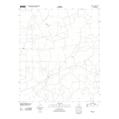
2010 Map of Benoit
USGS Topo · Published 2010About this map
Benoit and Blanton anchor this rural landscape in Runnels County, illustrating a classic West Texas pattern of dispersed agricultural settlement. The terrain is defined by a dense network of intermittent watercourses, including Mustang Creek, Middle Mustang Creek, and Hog Creek, which carve through the land before feeding into larger drainages. These creek beds and hollows, such as Dry Hollow and Wire Hollow, dictate the placement of county roads and the boundaries of large landholdings.
Find a feature on this map
33 named features on this map. Tap any name to fly to it.
Don’t see what you’re looking for? This feature index may not catch every label — zoom into the map to look around manually.
Map Details
Editions of this 2010 Benoit Map
This is the sole edition of this map. No revisions or reprints were ever made.
Other maps of this area

1892 · Ballinger
USGS Topo · 1:125,000

1921 · Hatchel
USGS Topo · 1:31,680

1921 · Spur Creek
USGS Topo · 1:31,680

1932 · Voss
USGS Topo · 1:62,500

1932 · Paint Rock
USGS Topo · 1:62,500

1954 · Brownwood
USGS Topo · 1:250,000
1967 · Hatchel
USGS Topo · 1:24,000

1967 · Talpa
USGS Topo · 1:24,000

1967 · Novice West
USGS Topo · 1:24,000
1967 · Little Grape Creek
USGS Topo · 1:24,000