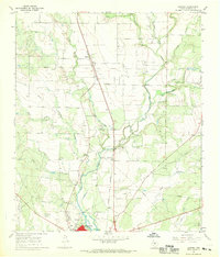
1967 Map of Hatchel
USGS Topo · Published 1969About this map
Hatchel and the northern reaches of Ballinger anchor this late-1960s landscape, where the Abilene and Southern railroad cuts a diagonal line across the central plains. This era reveals a community balanced between rural agriculture and town life, evidenced by the cluster of local amenities near the southern edge including the Rodeo Ground, a Drive-in Theater, and a Pumping Sta. The meandering course of Elm Creek and Coyote Creek provides the primary drainage for the region, while numerous Gravel Pits indicate active local industry.
Find a feature on this map
25 named features on this map. Tap any name to fly to it.
Don’t see what you’re looking for? This feature index may not catch every label — zoom into the map to look around manually.
Map Details
Editions of this 1967 Hatchel Map
2 editions found
Other maps of this area

1891 · Hayrick
USGS Topo · 1:125,000

1892 · Ballinger
USGS Topo · 1:125,000

1894 · Hayrick
USGS Topo · 1:125,000

1921 · Hatchel
USGS Topo · 1:31,680

1921 · Quarry Creek
USGS Topo · 1:31,680

1921 · Spur Creek
USGS Topo · 1:31,680

1921 · Rowena
USGS Topo · 1:31,680

1932 · Paint Rock
USGS Topo · 1:62,500

1954 · Brownwood
USGS Topo · 1:250,000

1954 · San Angelo
USGS Topo · 1:250,000