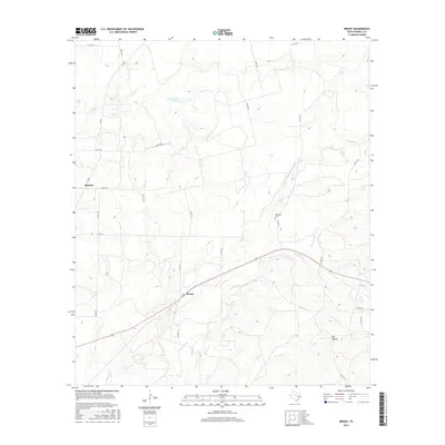
2016 Map of Benoit
USGS Topo · Published 2016About this map
Benoit serves as a central anchor in this agricultural landscape of eastern Runnels County, situated at the intersection of several country roads. The terrain is defined by a dense network of seasonal drainages, most notably Mustang Cr and its tributaries, including Middle Mustang Cr and Cow Br, which carve through the land towards Dry Hollow. To the northwest, the settlement of Blanton and the waters of Northington Lake suggest the dispersed nature of local ranching and farming operations during this era. Genealogists and local historians will find the Norwood Cem located along Co Rd 157, a significant landmark for tracing early families in the region. The map reflects a landscape where water management and transportation routes like FM 382 and Co Rd 136 have long dictated the rhythm of rural life.
Find a feature on this map
30 named features on this map. Tap any name to fly to it.
Don’t see what you’re looking for? This feature index may not catch every label — zoom into the map to look around manually.
Map Details
Editions of this 2016 Benoit Map
This is the sole edition of this map. No revisions or reprints were ever made.
Other maps of this area

1892 · Ballinger
USGS Topo · 1:125,000

1921 · Hatchel
USGS Topo · 1:31,680

1921 · Spur Creek
USGS Topo · 1:31,680

1932 · Voss
USGS Topo · 1:62,500

1932 · Paint Rock
USGS Topo · 1:62,500

1954 · Brownwood
USGS Topo · 1:250,000
1967 · Hatchel
USGS Topo · 1:24,000

1967 · Talpa
USGS Topo · 1:24,000

1967 · Novice West
USGS Topo · 1:24,000
1967 · Little Grape Creek
USGS Topo · 1:24,000