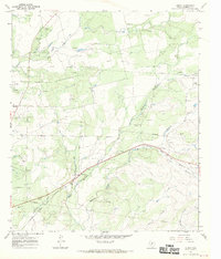
1967 Map of Benoit
USGS Topo · Published 1970About this map
The Atchison Topeka and Santa Fe railroad cuts a diagonal path through this portion of Runnels County, serving the small community of Benoit. This 1967 field-checked survey reveals a landscape defined by its watercourses and petroleum industry. Numerous Oil Wells and a designated Oil Field are concentrated in the west, while a network of creeks including Mud Creek, Hog Creek, and the multiple branches of Mustang Creek drain the undulating terrain. A Roadside Park and the Norwood Cem provide points of interest for genealogists and local historians, while the inclusion of the Blanton settlement area further north documents the rural development patterns of the late 1960s. The map also captures extensive infrastructure, from various Gravel Pits to several prominent Pipelines traversing the ranch land.
Find a feature on this map
26 named features on this map. Tap any name to fly to it.
Don’t see what you’re looking for? This feature index may not catch every label — zoom into the map to look around manually.
Map Details
Editions of this 1967 Benoit Map
This is the sole edition of this map. No revisions or reprints were ever made.
Other maps of this area

1892 · Ballinger
USGS Topo · 1:125,000

1921 · Hatchel
USGS Topo · 1:31,680

1921 · Spur Creek
USGS Topo · 1:31,680

1932 · Voss
USGS Topo · 1:62,500

1932 · Paint Rock
USGS Topo · 1:62,500

1954 · Brownwood
USGS Topo · 1:250,000
1967 · Hatchel
USGS Topo · 1:24,000

1967 · Talpa
USGS Topo · 1:24,000

1967 · Novice West
USGS Topo · 1:24,000
1967 · Little Grape Creek
USGS Topo · 1:24,000