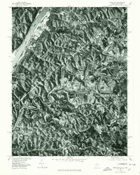
1975 Map of Bens Run
USGS Topo · Published 1979About this map
The Ohio River corridor serves as the primary artery for settlement and industry in this 1975 aerial orthophotograph. Along the river's eastern bank, the communities of Bens Run and Beavertown are clearly visible, illustrating the traditional river-oriented development patterns of the region. This orthophotoquad, produced by the Geological Survey and Soil Conservation Service, offers a unique photographic perspective on the land use of the mid-1970s. While the riverfront is characterized by industrial facilities and residential clusters, the interior is dominated by the dramatic, winding course of Middle Island Creek, which snakes through the wooded ridges and valleys. The contrast between the straightened engineering of the riverfront and the deep, natural oxbows of the inland creek provides a clear view of how topography dictated West Virginia's expansion during this era.
Find a feature on this map
4 named features on this map. Tap any name to fly to it.
Don’t see what you’re looking for? This feature index may not catch every label — zoom into the map to look around manually.
Map Details
Editions of this 1975 Bens Run Map
This is the sole edition of this map. No revisions or reprints were ever made.
Other maps of this area

1905 · West Union
USGS Topo · 1:62,500

1905 · New Matamoras
USGS Topo · 1:62,500

1906 · Saint Marys
USGS Topo · 1:62,500

1906 · New Martinsville
USGS Topo · 1:62,500

1924 · St Marys
USGS Topo · 1:62,500

1924 · New Martinsville
USGS Topo · 1:62,500

1924 · New Matamoras
USGS Topo · 1:62,500

1924 · West Union
USGS Topo · 1:62,500

1926 · New Martinsville
USGS Topo · 1:62,500

1926 · New Matamoras
USGS Topo · 1:62,500