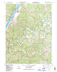
1994 Map of Bens Run
USGS Topo · Published 1998About this map
Middle Island Creek winds in a tight, serpentine path through the center of this map, creating a distinct landscape of isolated ridges and alluvial bottoms. On the western edge, the Ohio River serves as the industrial and transport corridor, home to Lock and Dam No 16 and the settlement of Bens Run. The presence of the Salt Evaporator Res near the riverbank highlights the region's historical reliance on mineral extraction and brine processing. Inland, the rugged terrain is defined by a series of parallel heights such as Federal Ridge and Oak Grove Ridge, where small communities and family landmarks are concentrated. Genealogists will find numerous rural burial grounds and places of worship, including Oak Grove Ch and Bibbys Cem, which represent the spiritual and social foundations of the area's late 20th-century rural life.
Find a feature on this map
45 named features on this map. Tap any name to fly to it.
Don’t see what you’re looking for? This feature index may not catch every label — zoom into the map to look around manually.
Map Details
Editions of this 1994 Bens Run Map
This is the sole edition of this map. No revisions or reprints were ever made.
Other maps of this area

1905 · West Union
USGS Topo · 1:62,500

1905 · New Matamoras
USGS Topo · 1:62,500

1906 · Saint Marys
USGS Topo · 1:62,500

1906 · New Martinsville
USGS Topo · 1:62,500

1924 · St Marys
USGS Topo · 1:62,500

1924 · New Martinsville
USGS Topo · 1:62,500

1924 · New Matamoras
USGS Topo · 1:62,500

1924 · West Union
USGS Topo · 1:62,500

1926 · New Martinsville
USGS Topo · 1:62,500

1926 · New Matamoras
USGS Topo · 1:62,500