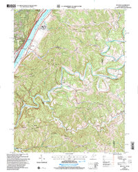
2002 Map of Bens Run
USGS Topo · Published 2006About this map
Middle Island Creek winds through the eastern portion of this West Virginia landscape, reflecting a rugged topography dominated by ridges like Oak Grove Ridge and Federal Ridge. The western border follows the Ohio River, where industrial and navigational infrastructure is prominent near Long Reach and Bens Run. Here, the Ohio River RR and State Hwy 2 parallel the water, connecting riverside settlements with sites like Lock and Dam No 16 and the Salt Wells near Engle. Away from the river, the map reveals a interior of small rural communities and mountain gaps. Genealogists will find numerous landmark churches and burial sites, including Mt Nebo Ch, Mt Welcome Ch, and Bibbys Cem. The terrain is characterized by steep valleys carved by waterways like Sugar Run and French Creek, leading to isolated settlements such as Arvilla and Shiloh.
Find a feature on this map
42 named features on this map. Tap any name to fly to it.
Don’t see what you’re looking for? This feature index may not catch every label — zoom into the map to look around manually.
Map Details
Editions of this 2002 Bens Run Map
This is the sole edition of this map. No revisions or reprints were ever made.
Other maps of this area

1905 · West Union
USGS Topo · 1:62,500

1905 · New Matamoras
USGS Topo · 1:62,500

1906 · Saint Marys
USGS Topo · 1:62,500

1906 · New Martinsville
USGS Topo · 1:62,500

1924 · St Marys
USGS Topo · 1:62,500

1924 · New Martinsville
USGS Topo · 1:62,500

1924 · New Matamoras
USGS Topo · 1:62,500

1924 · West Union
USGS Topo · 1:62,500

1926 · New Martinsville
USGS Topo · 1:62,500

1926 · New Matamoras
USGS Topo · 1:62,500