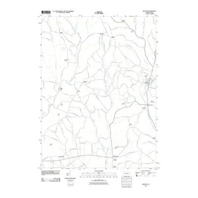
2010 Map of Benton
USGS Topo · Published 2010About this map
Fishing Creek and its many tributaries, including Little Fishing Creek and Green Creek, carve a landscape defined by prominent ridges and deep hollows in this northern Pennsylvania survey. Small historic hamlets like Rohrsburg, Greenwood, and Talmar are connected by a network of rural roads such as Mendenhall Hill Rd and Kessler Hollow Rd, reflecting the area's agricultural and milling roots. Local history is anchored at the Rohrsburg Cemetery and the site of Coles Mill, while the presence of the Benton Airport near Benton highlights the modern transition of the valley. Significant terrain features including Huckleberry Ridge, Bald Hill, and Bunker Hill rise above the stream beds, offering a clear view of the topographic character that shaped the settlement patterns of the township.
Find a feature on this map
114 named features on this map. Tap any name to fly to it.
Don’t see what you’re looking for? This feature index may not catch every label — zoom into the map to look around manually.
Map Details
Editions of this 2010 Benton Map
This is the sole edition of this map. No revisions or reprints were ever made.
Other maps of this area

1894 · Bloomsburg
USGS Topo · 1:62,500

1927 · Eagles Mere
USGS Topo · 1:48,000

1932 · Eagle Mere
USGS Topo · 1:62,500

1934 · Laporte
USGS Topo · 1:62,500

1935 · Hughesville
USGS Topo · 1:62,500

1947 · Bloomsburg
USGS Topo · 1:24,000

1947 · Stillwater
USGS Topo · 1:24,000
1947 · Mifflinville
USGS Topo · 1:24,000

1947 · Benton
USGS Topo · 1:31,680
1953 · Bloomsburg
USGS Topo · 1:24,000