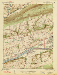
1947 Map of Mifflinville
USGS Topo · Published 1947About this map
The Susquehanna River carves through Columbia County, anchoring a landscape defined by riverside settlements and the Delaware Lackawanna and Western railroad. On the southern bank, Mifflinville sits across from Lime Ridge, where a prominent Quarry and Gravel Pit indicate the local industrial activity of the late 1940s. The northern terrain is dominated by the ridges of Huntington Mountain and Lee Mountain, sheltering small hamlets like Evansville and Fowlersville.
Find a feature on this map
42 named features on this map. Tap any name to fly to it.
Don’t see what you’re looking for? This feature index may not catch every label — zoom into the map to look around manually.
Map Details
Editions of this 1947 Mifflinville Map
2 editions found
Other maps of this area

1889 · Catawissa
USGS Topo · 1:62,500

1892 · Catawissa
USGS Topo · 1:62,500

1892 · Mahanoy
USGS Topo · 1:62,500

1893 · Mahanoy
USGS Topo · 1:62,500

1894 · Catawissa
USGS Topo · 1:62,500

1894 · Shickshinny
USGS Topo · 1:62,500

1894 · Bloomsburg
USGS Topo · 1:62,500

1946 · Shickshinny
USGS Topo · 1:31,680

1946 · Berwick
USGS Topo · 1:31,680

1947 · Bloomsburg
USGS Topo · 1:24,000