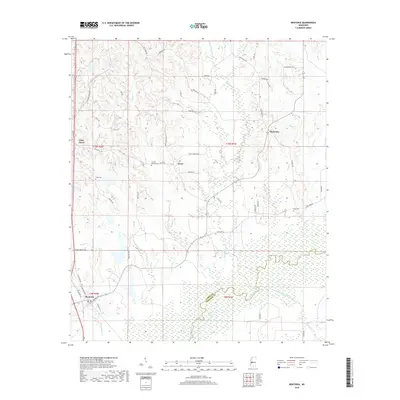
2018 Map of Bentonia
USGS Topo · Published 2018About this map
The Big Black River forms a significant natural boundary in the southern portion of this landscape, separating the bottomlands of Yazoo Co and Madison Co. Near this riverine border, Catfish Lake and a series of smaller wetlands sit alongside Persimmon Creek, indicating a low-lying, water-dominant environment. To the north, the terrain transitions into a network of creek drainages including Walesheba Cr and Indian Cr, where small settlements like Dover and Myrleville are established along secondary roads.
Find a feature on this map
58 named features on this map. Tap any name to fly to it.
Don’t see what you’re looking for? This feature index may not catch every label — zoom into the map to look around manually.
Map Details
Editions of this 2018 Bentonia Map
This is the sole edition of this map. No revisions or reprints were ever made.
Other maps of this area

1955 · Jackson
USGS Topo · 1:250,000

1961 · Jackson
USGS Topo · 1:250,000

1961 · Canton
USGS Topo · 1:62,500

1961 · Valley
USGS Topo · 1:62,500

1962 · Jackson
USGS Topo · 1:250,000

1962 · Flora
USGS Topo · 1:62,500

1964 · Linwood
USGS Topo · 1:24,000
1966 · Vaughan
USGS Topo · 1:62,500

1984 · Yazoo City
USGS Topo · 1:100,000
1988 · Benton
USGS Topo · 1:24,000