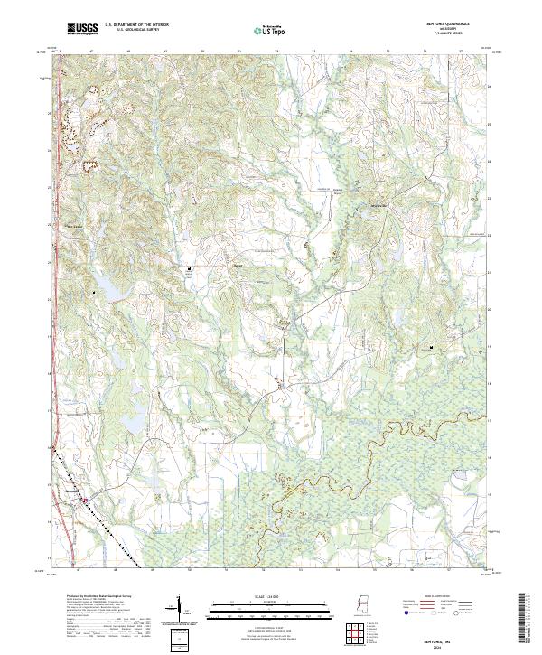
2024 Map of Bentonia
USGS Topo · Published 2024About this map
The Big Black River meanders across the southeastern corner of this landscape, forming the natural boundary between Yazoo and Madison counties. The town of Bentonia serves as a focal point in the southwest, characterized by a grid of streets including Cannon Ave and E Railroad Ave that run parallel to the transport corridor. Moving north, the terrain transitions into a more dispersed settlement pattern where small communities like Little Yazoo, Dover, and Myrleville are connected by a network of local roads such as Old Dover Rd and Paradise Rd. For those tracing family histories, several burial grounds are scattered throughout the countryside, including Central Holmes Cem, Cage Cem, and Days Cem. The drainage network is particularly dense here, with Walesheba Creek, Indian Creek, and Wolf Creek cutting through the uplands before reaching the river bottomlands near Catfish Lake.
Find a feature on this map
57 named features on this map. Tap any name to fly to it.
Don’t see what you’re looking for? This feature index may not catch every label — zoom into the map to look around manually.
Map Details
Editions of this 2024 Bentonia Map
This is the sole edition of this map. No revisions or reprints were ever made.
Other maps of this area

1955 · Jackson
USGS Topo · 1:250,000

1961 · Jackson
USGS Topo · 1:250,000

1961 · Canton
USGS Topo · 1:62,500

1961 · Valley
USGS Topo · 1:62,500

1962 · Jackson
USGS Topo · 1:250,000

1962 · Flora
USGS Topo · 1:62,500

1964 · Linwood
USGS Topo · 1:24,000
1966 · Vaughan
USGS Topo · 1:62,500

1984 · Yazoo City
USGS Topo · 1:100,000
1988 · Benton
USGS Topo · 1:24,000