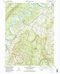
1994 Map of Bentonville
USGS Topo · Published 1997About this map
The South Fork Shenandoah River carves a dramatic serpentine path through this 1990s-era landscape, where the valley floor transitions into the protected highlands of Shenandoah National Park and the George Washington National Forest. Small communities like Bentonville and Limeton are situated along the Norfolk and Western rail corridor, while river access points at Bentonville Landing and Karo Landing highlight the waterway's enduring importance.
Find a feature on this map
57 named features on this map. Tap any name to fly to it.
Don’t see what you’re looking for? This feature index may not catch every label — zoom into the map to look around manually.
Map Details
Editions of this 1994 Bentonville Map
This is the sole edition of this map. No revisions or reprints were ever made.
Other maps of this area

1893 · Luray
USGS Topo · 1:125,000

1905 · Luray
USGS Topo · 1:125,000

1929 · Stony Man
USGS Topo · 1:48,000

1933 · Stony Man
USGS Topo · 1:62,500

1939 · Front Royal
USGS Topo · 1:48,000

1944 · Front Royal
USGS Topo · 1:62,500

1947 · Strasburg
USGS Topo · 1:62,500

1949 · Charlottesville
USGS Topo · 1:250,000

1950 · Strasburg
USGS Topo · 1:62,500

1956 · Charlottesville
USGS Topo · 1:250,000