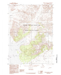
1985 Map of Bering Glacier A-1
USGS Topo · Published 1985About this map
Malaspina Glacier and its massive moraine field dominate this coastal Alaskan landscape during the mid-1980s. The survey illustrates the glacial retreat and ice movement within the Wrangell - Saint Elias National Park and the adjacent Wrangell - Saint Elias Wilderness. Water from the melting ice feeds the Chaix River and the scattered Agassiz Lakes, while the western edge of the sheet opens into Icy Bay and Taan Fiord. A small Air Strip located near the moraine edges provides the only clear evidence of human infrastructure in this remote ice-and-water environment. Several other ice bodies, including the Tyndall Glacier, Yahtse Glacier, Daisy Glacier, and Coal Glacier, are shown in their 1970s aerial-surveyed positions, providing a baseline for studying the shifting coastlines and ice fronts of the Gulf of Alaska.
Find a feature on this map
15 named features on this map. Tap any name to fly to it.
Don’t see what you’re looking for? This feature index may not catch every label — zoom into the map to look around manually.
Map Details
Editions of this 1985 Bering Glacier A-1 Map
This is the sole edition of this map. No revisions or reprints were ever made.
Other maps of this area

1948 · Icy Bay D-2 and D-3
USGS Topo · 1:63,360

1950 · Bering Glacier
USGS Topo · 1:250,000

1950 · Icy Bay
USGS Topo · 1:250,000

1951 · Icy Bay D-2 and D-3
USGS Topo · 1:63,360

1951 · Icy Bay
USGS Topo · 1:250,000

1951 · Bering Glacier
USGS Topo · 1:250,000

1951 · Bering Glacier A-2
USGS Topo · 1:63,360

1951 · Yakutat
USGS Topo · 1:250,000

1951 · Mt Saint Elias
USGS Topo · 1:250,000

1959 · Yakutat
USGS Topo · 1:250,000