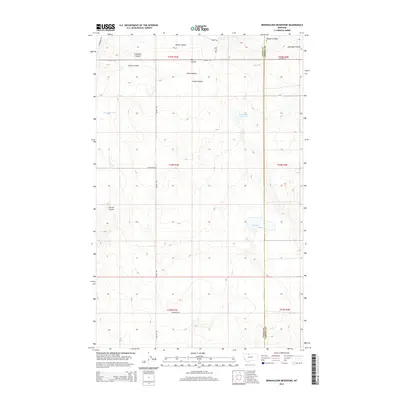
2014 Map of Berkholder Reservoir
USGS Topo · Published 2014About this map
Berkholder Reservoir and the drainage of Big Coulee define this high-plains landscape along the border of Toole and Liberty Counties. This modern topographic study reveals a terrain of deeply cut erosional features, known locally as coulees, which segment the agricultural and grazing lands. Named drainages such as Grandma Coulee, Fernell Coulee, and Antelope Coulee provide critical landmarks across the township and range system. The map documents a sparsely populated rural infrastructure where essential water management features like Big Dam and Mary Reservoir support the arid region's land use. Transportation is anchored by local connectors like Oilmont Hwy and several named gravel routes, including Gus Blaze Rd and Markuson Rd, which follow the section lines of this northern Montana landscape.
Find a feature on this map
27 named features on this map. Tap any name to fly to it.
Don’t see what you’re looking for? This feature index may not catch every label — zoom into the map to look around manually.
Map Details
Editions of this 2014 Berkholder Reservoir Map
This is the sole edition of this map. No revisions or reprints were ever made.
Other maps of this area
1954 · Shelby
USGS Topo · 1:250,000
1958 · Shelby
USGS Topo · 1:250,000
1962 · Cameron Lake
USGS Topo · 1:24,000
1962 · North Lothair School
USGS Topo · 1:24,000
1962 · Hawthorne School
USGS Topo · 1:24,000
1962 · Berkholder Reservoir
USGS Topo · 1:24,000
1962 · Mc Carters Lake
USGS Topo · 1:24,000
1962 · Blair Ranch
USGS Topo · 1:24,000
1962 · Haystack Butte
USGS Topo · 1:24,000
1962 · Mc Carters Lake SE
USGS Topo · 1:24,000