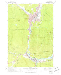
1970 Map of Berlin
USGS Topo · Published 1972About this map
The Androscoggin River carves a deep industrial and transportation corridor through this mountain landscape, anchoring the bustling centers of Berlin and Gorham. During the early 1970s, the region's character was defined by the intersection of heavy rail lines—the Grand Trunk and the Boston and Maine—and the vast timberlands of the White Mountain National Forest. The map reveals a dense social infrastructure in Berlin, featuring numerous parochial institutions like Notre Dame High Sch and St Patricks church, alongside a cluster of burial grounds including Mt Calvaire Cem and St Kieran Cem. To the south, the village of Gorham sits at the confluence near Libby Airfield, while the Mahoosuc Range rises sharply to the east, punctuated by landmarks such as Cascade Mtn and Mascot Pond.
Find a feature on this map
69 named features on this map. Tap any name to fly to it.
Don’t see what you’re looking for? This feature index may not catch every label — zoom into the map to look around manually.
Map Details
Editions of this 1970 Berlin Map
4 editions found
Other maps of this area

1893 · Mt. Washington
USGS Topo · 1:62,500

1893 · Gorham
USGS Topo · 1:62,500

1896 · Mt. Washington
USGS Topo · 1:62,500

1896 · Gorham
USGS Topo · 1:62,500

1930 · Milan
USGS Topo · 1:62,500

1930 · Percy
USGS Topo · 1:62,500

1933 · Milan
USGS Topo · 1:62,500

1934 · Percy
USGS Topo · 1:62,500

1934 · Milan
USGS Topo · 1:62,500

1935 · Mt. Washington
USGS Topo · 1:62,500