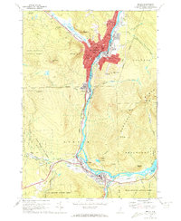
1970 Map of Berlin
USGS Topo · Published 1972About this map
Industrial and community life in the Androscoggin River valley centers on the city of Berlin and the town of Gorham. This 1970 field-checked survey reveals a landscape of high elevation peaks like Mt Hayes and Mt Forest alongside deep-seated manufacturing and transit corridors. The influence of French-Canadian settlement is evident in the cluster of parochial institutions, including Notre Dame High Sch and Mt Calvaire Cem. Commercial transport is dominated by the Grand Trunk and Boston and Maine railroads, which parallel the river through narrow gaps in the Mahoosuc Range. Between the urban centers, the Moose Brook State Forest and several Gravel Pits show the varied uses of the land. Further south, Upper Village and Libby Airfield mark the southern reach of this mountain valley corridor.
Find a feature on this map
72 named features on this map. Tap any name to fly to it.
Don’t see what you’re looking for? This feature index may not catch every label — zoom into the map to look around manually.
Map Details
Editions of this 1970 Berlin Map
4 editions found
Other maps of this area

1893 · Mt. Washington
USGS Topo · 1:62,500

1893 · Gorham
USGS Topo · 1:62,500

1896 · Mt. Washington
USGS Topo · 1:62,500

1896 · Gorham
USGS Topo · 1:62,500

1930 · Milan
USGS Topo · 1:62,500

1930 · Percy
USGS Topo · 1:62,500

1933 · Milan
USGS Topo · 1:62,500

1934 · Percy
USGS Topo · 1:62,500

1934 · Milan
USGS Topo · 1:62,500

1935 · Mt. Washington
USGS Topo · 1:62,500