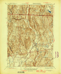
1946 Map of Bernardston
USGS Topo · Published 1946About this map
The Falls River valley serves as the central artery of this mid-1940s landscape, where the town of Bernardston anchors a network of rural schoolhouses and family-named summits. The settlement pattern reflects an era of localized education and agriculture, evidenced by dispersed landmarks like the Baker Sch, Sunnyside Sch, and the East Bernardston Sch. Higher elevations are defined by prominent peaks including Wildcat Mtn and East Mtn, while the eastern edge is preserved within the Northfield State Forest.
Find a feature on this map
54 named features on this map. Tap any name to fly to it.
Don’t see what you’re looking for? This feature index may not catch every label — zoom into the map to look around manually.
Map Details
Editions of this 1946 Bernardston Map
2 editions found
Other maps of this area

1887 · Warwick
USGS Topo · 1:62,500

1889 · Warwick
USGS Topo · 1:62,500

1890 · Greenfield
USGS Topo · 1:62,500

1891 · Brattleboro
USGS Topo · 1:62,500

1893 · Brattleboro
USGS Topo · 1:62,500

1894 · Greenfield
USGS Topo · 1:62,500

1894 · Warwick
USGS Topo · 1:62,500

1898 · Keene
USGS Topo · 1:62,500

1932 · Brattleboro
USGS Topo · 1:48,000

1932 · Warwick
USGS Topo · 1:48,000