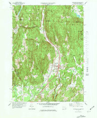
1977 Map of Bernardston
USGS Topo · Published 1979About this map
Fall River carves a central path through this landscape near the Massachusetts and Vermont border, where the Boston and Maine Railroad follows the valley floor toward North Bernardston. The terrain is defined by prominent elevations like Wildcat Mtn and West Mtn, which frame the settled corridor of Bernardston. Local genealogy and land use are evidenced by several burial grounds, including Beaver Meadow Cem and East Hill Cem, and the presence of Cushman Park and the Northfield State Forest. To the south, water management is visible at the Greenfield Reservoir and its associated Filtration Plant. The transition from rural hilly terrain to structured settlement at Interchange 28 illustrates the evolution of regional infrastructure as it appeared in the late 1970s.
Find a feature on this map
72 named features on this map. Tap any name to fly to it.
Don’t see what you’re looking for? This feature index may not catch every label — zoom into the map to look around manually.
Map Details
Editions of this 1977 Bernardston Map
Other maps of this area

1887 · Warwick
USGS Topo · 1:62,500

1889 · Warwick
USGS Topo · 1:62,500

1890 · Greenfield
USGS Topo · 1:62,500

1891 · Brattleboro
USGS Topo · 1:62,500

1893 · Brattleboro
USGS Topo · 1:62,500

1894 · Greenfield
USGS Topo · 1:62,500

1894 · Warwick
USGS Topo · 1:62,500

1898 · Keene
USGS Topo · 1:62,500

1932 · Brattleboro
USGS Topo · 1:48,000

1932 · Warwick
USGS Topo · 1:48,000