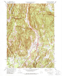
1977 Map of Bernardston
USGS Topo · Published 1988About this map
The Fall River cuts a prominent north-south path through this borderland, where the village of Bernardston serves as a central hub at the junction of modern infrastructure and rural tradition. The landscape is defined by its transit history, following the Boston and Maine rail line as it skirts the western base of West Mtn and Wildcat Mtn. Genealogists will find notable burial grounds such as the Old Cem near the town center and the Beaver Meadow Cem to the northwest, while the presence of a Covered Bridge near the Green River highlights the enduring character of local engineering.
Find a feature on this map
54 named features on this map. Tap any name to fly to it.
Don’t see what you’re looking for? This feature index may not catch every label — zoom into the map to look around manually.
Map Details
Editions of this 1977 Bernardston Map
Other maps of this area

1887 · Warwick
USGS Topo · 1:62,500

1889 · Warwick
USGS Topo · 1:62,500

1890 · Greenfield
USGS Topo · 1:62,500

1891 · Brattleboro
USGS Topo · 1:62,500

1893 · Brattleboro
USGS Topo · 1:62,500

1894 · Greenfield
USGS Topo · 1:62,500

1894 · Warwick
USGS Topo · 1:62,500

1898 · Keene
USGS Topo · 1:62,500

1932 · Brattleboro
USGS Topo · 1:48,000

1932 · Warwick
USGS Topo · 1:48,000