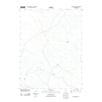
2011 Map of Bernice Canyon
USGS Topo · Published 2011About this map
Bernice Canyon and its namesake Bernice Creek dominate this 2011 topographic study of Churchill County, Nevada. The landscape is defined by a network of drainage systems that have carved deep into the terrain, creating distinct landforms such as Mud Spring Canyon and Hoyt Canyon. These natural features dictate the sparse infrastructure of the region, where roads like E Valley Rd and the Hoyt Cyn trail follow the contours of the land.
Find a feature on this map
10 named features on this map. Tap any name to fly to it.
Don’t see what you’re looking for? This feature index may not catch every label — zoom into the map to look around manually.
Map Details
Editions of this 2011 Bernice Canyon Map
This is the sole edition of this map. No revisions or reprints were ever made.
Other maps of this area

1955 · Millett
USGS Topo · 1:250,000

1959 · Millett
USGS Topo · 1:250,000

1966 · Clan Alpine Ranch
USGS Topo · 1:62,500

1966 · Humboldt Salt Marsh
USGS Topo · 1:62,500

1966 · Shoshone Meadows
USGS Topo · 1:62,500

1966 · Edwards Creek Valley
USGS Topo · 1:62,500

1983 · Edwards Creek Valley
USGS Topo · 1:100,000
1990 · Hole In The Wall
USGS Topo · 1:24,000
1990 · Bernice Canyon
USGS Topo · 1:24,000
1990 · Byers Canyon
USGS Topo · 1:24,000