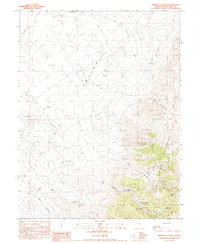
1990 Map of Bernice Canyon
USGS Topo · Published 1990About this map
Clan Alpine Mountains dominate the eastern reaches of this Churchill County landscape, rising sharply above the flat expanse of Dixie Valley. This region is defined by its deep mining history, with several named operations such as the King Solomon Mine and the Antimony King Mine situated along the steep slopes of Bernice Canyon. The drainages of Shoshone Creek and Bernice Creek carve through the arid terrain, leading toward several springs that provided essential water sources for the remote mining claims of the era. The mapping of Hove Canyon and Spring Canyon reveals a complex network of geological features and prospecting sites, including the U-Bet Mine and Williams Mine, which illustrate the intensity of mineral exploration in the Great Basin during the mid-to-late 20th century.
Find a feature on this map
16 named features on this map. Tap any name to fly to it.
Don’t see what you’re looking for? This feature index may not catch every label — zoom into the map to look around manually.
Map Details
Editions of this 1990 Bernice Canyon Map
This is the sole edition of this map. No revisions or reprints were ever made.
Other maps of this area

1955 · Millett
USGS Topo · 1:250,000

1959 · Millett
USGS Topo · 1:250,000

1966 · Clan Alpine Ranch
USGS Topo · 1:62,500

1966 · Humboldt Salt Marsh
USGS Topo · 1:62,500

1966 · Shoshone Meadows
USGS Topo · 1:62,500

1966 · Edwards Creek Valley
USGS Topo · 1:62,500

1983 · Edwards Creek Valley
USGS Topo · 1:100,000
1990 · Hole In The Wall
USGS Topo · 1:24,000
1990 · Byers Canyon
USGS Topo · 1:24,000
1990 · Shoshone Meadows
USGS Topo · 1:24,000