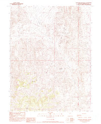
1990 Map of Shoshone Meadows
USGS Topo · Published 1990About this map
Shoshone Mountains topography dominates this late-twentieth-century study of the Churchill County high country. The landscape is defined by its drainage systems and mineral potential, with Shoshone Creek winding through the center of the sheet toward the lush Shoshone Meadows. This area served as a vital water source in an otherwise arid environment, supported by Shoshone Springs. Evidence of human industry is scattered across the slopes, specifically within the western canyons where multiple Mine and Prospect labels indicate a history of geological exploration. The terrain is marked by sharp elevation changes, particularly around Mud Canyon, reflecting the isolated character of the Nevada interior before modern development reached these higher elevations. This provisional survey captures the intersection of natural spring-fed oases and the extractive search for resources.
Find a feature on this map
8 named features on this map. Tap any name to fly to it.
Don’t see what you’re looking for? This feature index may not catch every label — zoom into the map to look around manually.
Map Details
Editions of this 1990 Shoshone Meadows Map
This is the sole edition of this map. No revisions or reprints were ever made.
Other maps of this area

1955 · Millett
USGS Topo · 1:250,000

1959 · Millett
USGS Topo · 1:250,000

1966 · Clan Alpine Ranch
USGS Topo · 1:62,500

1966 · Humboldt Salt Marsh
USGS Topo · 1:62,500

1966 · Shoshone Meadows
USGS Topo · 1:62,500

1966 · Edwards Creek Valley
USGS Topo · 1:62,500

1983 · Edwards Creek Valley
USGS Topo · 1:100,000
1990 · Hole In The Wall
USGS Topo · 1:24,000
1990 · Bernice Canyon
USGS Topo · 1:24,000
1990 · Byers Canyon
USGS Topo · 1:24,000